Southwest Road Trip Part 1: White Pocket

After a 7 hour drive from LA, we finally arrived at our hotel in Kanab at 1am. We had watched (with a little too much sleep-deprived, delirious astonishment than it probably deserved) the satellite clock in our Outback jump back and forth an hour as we entered and exited Arizona twice. We were going to be team Little Sleep and wake up early to get to the Kanab BLM Visitor Center at 8:30am sharp to enter the lottery for the ever elusive Wave. We had entered the online lottery twice before, but this was the first time we would attempt to enter in person.

That morning, there were 53 groups ranging from 2-6 people. The forecast for the next day was rain. Still, we were all determined. There were people from all over the world who had traveled a long way in hopes of being one of the lucky 10 chosen. Every group was assigned a number and with breaths held and fingers crossed tightly, we all watched as the bingo cage began to roll. Winners were called, followed by enthusiastic cheers and whooping. Sadly, we were not one of the lucky ones, but there was so much to explore in the area that as the BLM ranger would say in his well-rehearsed speech, "The Wave is only a drop in the bucket."

After the lottery, we had planned a trip to White Pocket with Dreamland Safari. (Shoutout to our awesome tour guide, Orion.) The deep, sandy road to get there is notoriously difficult to navigate, requiring a high clearance 4WD vehicle and off-roading skills. Plus, a $1000 towing fee was not something we wanted to risk. 

DSC_2666.jpg
DSC_2678.jpg

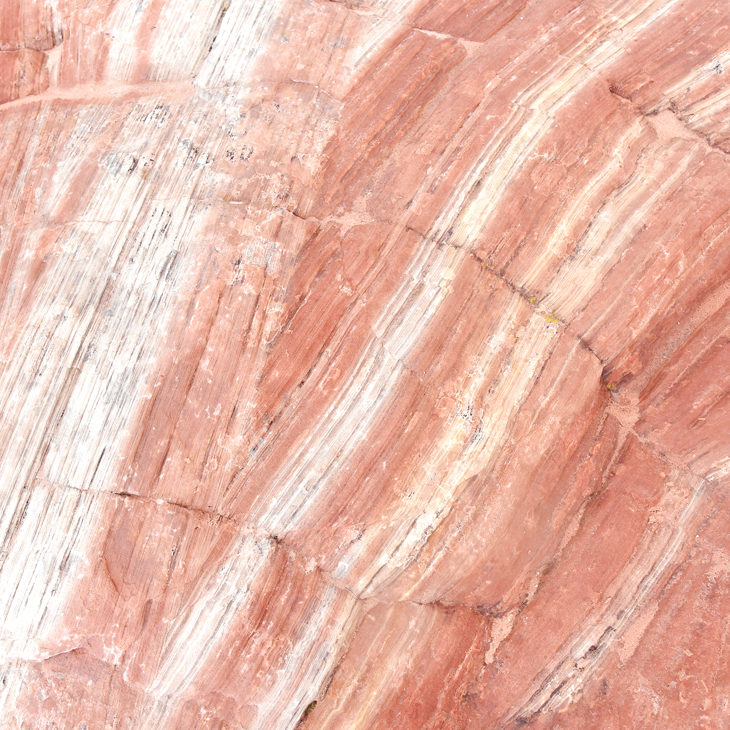
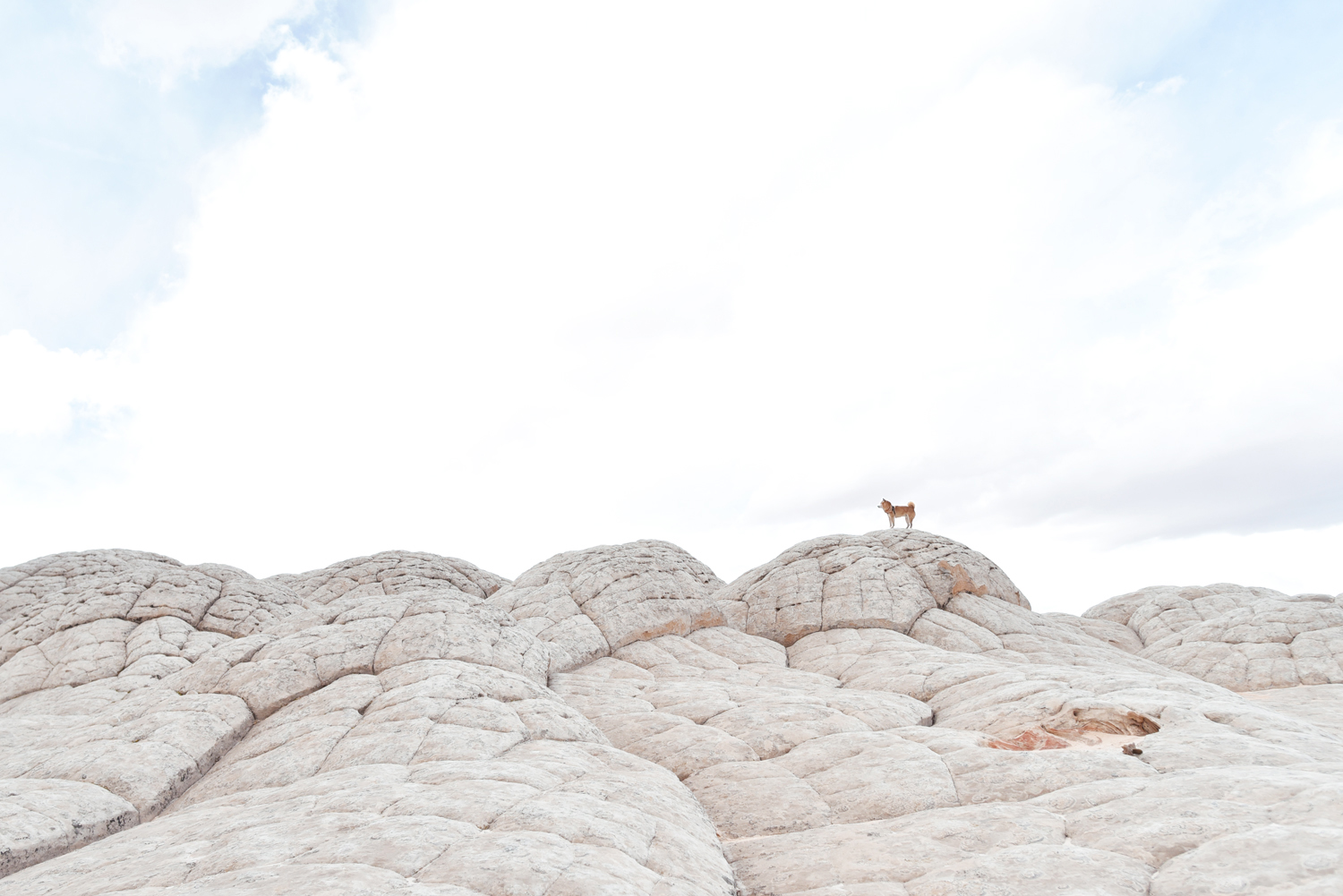
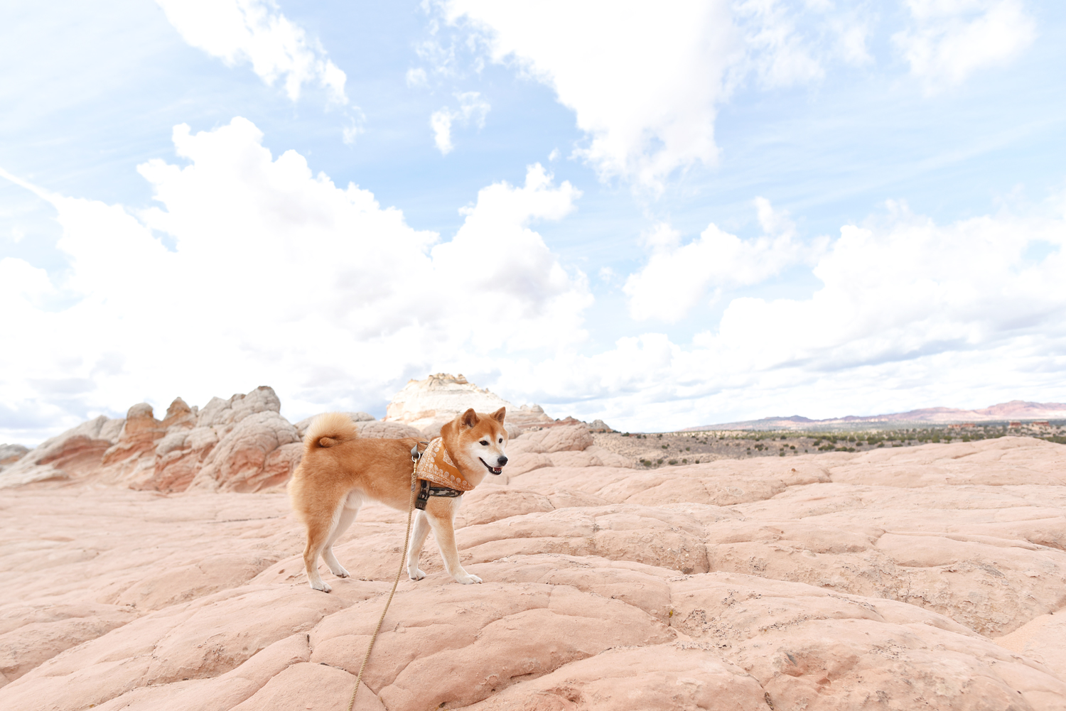
Situated on the Arizona side of the Utah-Arizona border and just a stone's throw from The Wave, White Pocket is a diverse and expansive, other-worldly, twisty, gnarly, holey, bulgy, stripy sandstone landscape ranging in color from whites and grays to all the shades of pale reds, yellows and oranges. White Pocket gets its name from the pockets of water that collect in large pools as well as its uniquely white, calcium-rich surrounding rock formations. Exploring the area does not require a permit and fortunately, the mere fact that it is so difficult to get to has been excellent for crowd control. (There is talk that a permit system may be instated in the future as the area gains popularity.)

DSC_3319.jpg
DSC_3309_2.jpg
DSC_3329.jpg

This red, striated slot canyon like section is The Wormhole. At the end of the Wormhole is a dark red dot called the Clamshell. The white, bulgy area with the famous lone tree is very appropriately called the brains. 

DSC_3280.jpg
DSC_3104.jpg
DSC_3196.jpg
DSC_3050.jpg
DSC_3240.jpg
DSC_3237_1.jpg
DSC_3155.jpg
DSC_2860_2.jpg
DSC_2813_2.jpg
DSC_2762.jpg

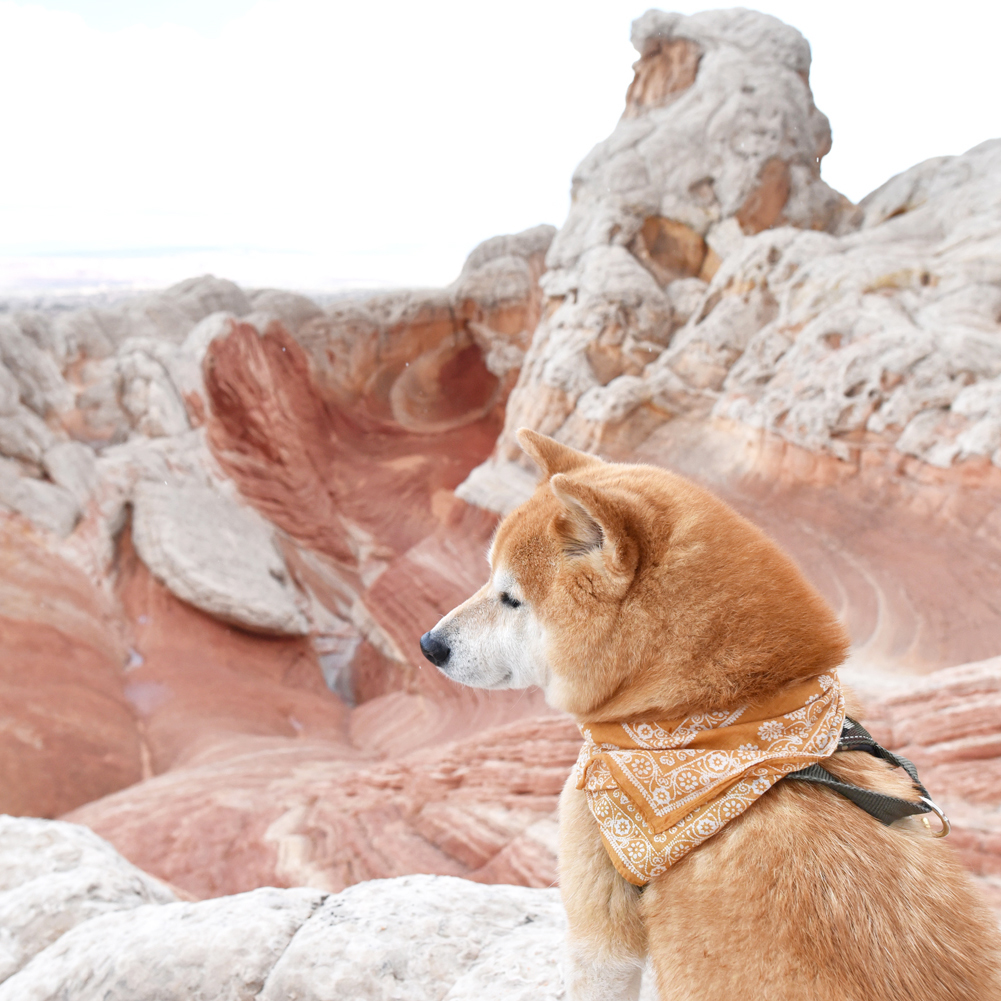
This pool of water and the surrounding white brain-like formation is how White Pocket got its name. To this day, ranchers in the area will take their cattle to this watering hole to drink as evidenced by the cow patties we found. 

DSC_2868.jpg

Two of the coolest things we saw were these beautiful petroglyphs of Bighorn Sheep preserved in the red sandstone and an almost perfect Native American chert arrowhead. 

DSC_2709_2.jpg
DSC_2724.jpg
DSC_2831.jpg
DSC_2965.jpg
DSC_2848.jpg
DSC_3091_2.jpg
DSC_2923.jpg

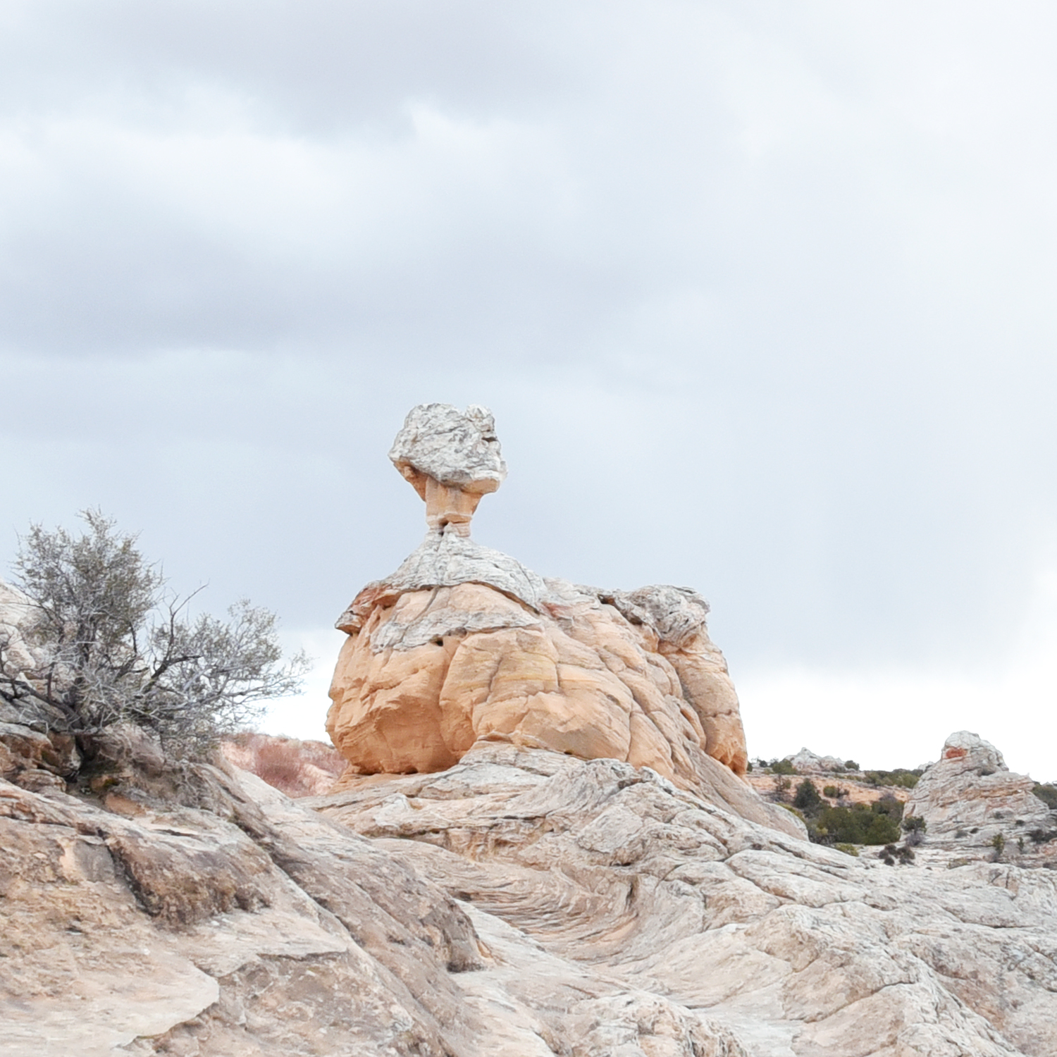
This rock formation with the candy-colored stripes is known as The Lollipop. 

DSC_2943.jpg
DSC_3251.jpg
DSC_3178.jpg
DSC_2798.jpg
DSC_2787.jpg

Halfway through the tour, we returned to the vehicle where a spread of cold cuts and fresh veggies were laid out for us to construct our own wraps and sandwiches. Not to be left out, Hoku munched on cucumbers and bell peppers.

It showered on us throughout the day, but the weather held up for the most part and it was fascinating to see the landscape in all sorts of light. David and I are already talking of returning to experience Dreamland's overnight camping tour. I can only imagine how stunning White Pocket is at sunrise and sunset. We couldn't have asked for a better way to kick off our Southwest adventure.

DSC_3467.jpg

February In Review

Here are some scenes from a whirlwind of a chilly February! 

DSC_1187.jpg

David and I "celebrated" Valentine's Day and Chinese New Year by being the sickest we've both been in three years. Tamiflu, Sudafed, Mucinex DM, and Tylenol were our best friends for a solid week. Thank you Winter Olympics, for being our sniffling, sneezing, coughing, aching, fever, best TV you ever got with a cold. Hoku was a trooper and put up with 5 minute walks, which consisted of us stumbling down our street like zombies until he pottied. And he never left my side as I slept three straight days away on the couch, though I suspect it was to make sure I didn't sleep through his mealtimes and forget to feed him.

DSC_1628.jpg
DSC_1622.jpg
DSC_1596.jpg

After much debate, we decided on this little espresso machine, which ended up being a surprise birthday gift from my mom. Thanks mom! David has been enjoying Americanos and I have been trying (and failing) at making the perfect flat white. Still working on the basics, like getting that perfectly textured milk froth.

DSC_1472.jpg
DSC_1564.jpg
DSC_1553.jpg

In the garden, our lettuce, baby bak choy and choy sum seedlings are thoroughly enjoying this cooler weather we've been having. These guys even survived a few mornings that dropped well below freezing whereas their garden bed neighbor, our wild tomato plant, did not stand a chance. We wished it luck in our compost bin before uprooting it to make room for carrots, beets and broccoli.

DSC_1209.jpg
DSC_1226.jpg
DSC_1300.jpg
DSC_1246.jpg

As a belated Valentine's Day treat after we recovered from the plague, I made molten chocolate cakes from scratch using these sweet, heart-shaped mini cocottes. They paired perfectly with not-made-from-scratch Trader Joe's vanilla ice cream. Should I dare to attempt soufflÊs next?

DSC_1014.jpg
DSC_1043.jpg

I've decided to set a new goal of baking a fresh loaf of bread every week. This is my go-to recipe because it is seriously so easy and pretty much guarantees a perfect, rustic-looking boule every single time. So many other breads on my list for next month: baguettes, sesame bagels and Hokkaido milk bread!

DSC_1313.jpg
DSC_1337.jpg
DSC_1382_1.jpg
DSC_1409.jpg

At the beginning of the month, we drove into Idyllwild for the first time since this trip back in 2014 for a hike up to the Tahquitz Peak fire lookout and declared it our new favorite short hike. (Sorry Baden-Powell.)

DSC_9835.jpg
DSC_9933.jpg
DSC_9535 copy.jpg

And finally, I celebrated my 33rd birthday with a 24 hour backpacking trip on Mt. San Gorgonio that ended with a starry morning hike that still feels incredibly surreal. It's hard to believe that one year ago, the thought of spending the night by ourselves, let alone hiking in the dark, on a mountain was all too terrifying. Here's to another year of facing fears and learning new things with my two best guys by my side. 

DSC_0475.jpg
DSC_0617 copy.jpg
DSC_0497 copy.jpg

Backpacking San Gorgonio Mountain Via Vivian Creek

Distance: 17 Miles  |  Elevation Gain: 5,840 Ft  |  Campsite: High Creek Camp

We pulled in to a pitch black trailhead parking lot at 5:30am, the headlights of our Outback eerily illuminating two other parked cars. It was the first time we'd be starting a hike in complete darkness and I was admittedly a little nervous. But as we left the warmth of our heated seats and stepped out into the brisk morning air, all apprehension was replaced by awe at an early morning sky full of stars that were definitely not visible when we left the city just a couple hours earlier. Shortly after, another vehicle arrived and I half jokingly asked David if he thought they were hikers or hooligans. "Do hooligans drive Land Rovers?" he replied, cool as a cucumber. Seconds later, two women stepped out in stylish hiking gear and we chuckled. Yep, definitely hooligans. With our packs strapped on and GPS activated, we walked out into the blackness to begin the first couple miles with just our headlamps, the moonlight and of course the sound of Shiba paws to guide the way. 

IMG_7214.jpg
IMG_7236.jpg

Halfway up the steep 1000' vertical ascent that begins after the Mill Creek crossing, there was finally enough light in the sky for us to ditch the headlamps. At the end of one of the switchbacks, there was an opening looking out over Mill Creek Canyon and we took a second to take in a well-earned view, just made all the sweeter by the glorious layers of a dawn sky.  

IMG_7250.jpg
IMG_7327.jpg

We reached Half Way Camp by 8am and debated whether to set up home base there or continue on another 2.5 miles to High Creek Camp, which would have significantly better views and is also the more popular of the two campsites. We decided to carry on and booked it to High Creek by 10am. 

IMG_7339.jpg
DSC_0399.jpg

The rangers had warned us of snow and ice starting from 7500' so we were fully expecting the possibility of camping on snow since High Creek sits at 9200'. To our pleasant surprise, most of the campsites were dry and we found ourselves a spot with a good view and decent wind protection. We pitched our tent, swapped our heavy packs out for lighter day packs all too gladly, and pressed onward for the final, dreadful 3 miles to the summit. I know 3 miles doesn't sound all that bad on paper, but imagine it at altitude (which makes breathing more labored) through ankle deep snow after hiking a good 6 miles with 25lb and 30lb packs. Let's just say that the only one having a grand old time the entire way up was the dude with four legs. 

DSC_0433.jpg
DSC_0435.jpg
DSC_0440.jpg
DSC_0442.jpg
DSC_0445.jpg
DSC_0456.jpg
DSC_0464.jpg
DSC_0469.jpg
DSC_0475.jpg

About a half mile from the summit as we were trudging up the windy, diagonal traverse below the ridge, we started noticing that some hikers ahead of us were turning around. I looked ahead to the saddle leading to summit and saw snow literally being blasted into the air and swirling around before disappearing into the wind. They had tried to figure out a way to pass, the (bigger and stronger than us) hiker said, but it was impossible to even stand up straight. We stared at the summit, visible in the distance, just calling to us like the one ring. We had come so far. But hey, 11,000' was just as good as 11,503' if it meant living another day. A mountain as high as San Gorgonio pretty much makes it's own weather, and if it decides that you shall not pass, you respect it. If you're wondering what the summit actually looks like, prepare to be not that awed by this photo we took back in 2015.

DSC_0507.jpg
PKAO7693.jpg
BGNT8058.jpg

So back down the mountain we went, a little disappointed but secretly a little relieved. Back in 2015, we had said "never again" to San Gorgonio, but here we were again, suckers for punishment. I had wondered since then if Hoku, being older than the first time he climbed this mountain with us, would ever be able to do it again. And the answer was a resounding yes. And he schooled us, just like the first time. And I'm pretty sure he could do it again in another three years.

DSC_0493.jpg
DSC_0617.jpg
DSC_0642.jpg
DSC_0801.jpg

We returned back down to 9200' to find our campsite awash with magic hour light. Using our new, super light Snow Peak LiteMax stove (which replaced our heavier Jetboil) we made and scarfed down a dinner of Backpacker's Pantry Kung Pao Rice with Chicken. While it was decently edible, I would not recommend it for cold weather, high altitude camping. Not only does it take twice as long to cook at higher altitudes, meaning that it will not be hot when you're finally able to eat it, it also includes these two packets of peanuts and chili flakes that are sealed in cold finger-proof, industrial grade thick plastic without easy to open tabs. A real PITA. 

The real treat was a cup of hot instant tofu miso soup that David so thoughtfully packed in the bear bin for me. My absolute favorite camp food. Next time, I'll pack a little ball of rice to add in and it'd be perfection. 

DSC_0668.jpg
DSC_0750 copy.jpg
DSC_0772.jpg
DSC_0741.jpg
DSC_0720.jpg
DSC_0762.jpg

↑A beautiful view of the "switchbacks of death" from our camp. 

DSC_0576.jpg
DSC_0806.jpg
DSC_0873 copy.jpg
DSC_0856 copy.jpg
DSC_0893 copy.jpg

We watched the sky change from a fiery orange to vibrant purples and pinks before calling it an early night, tucking into our sleeping bags at about 7pm. The winds gusted sporadically and we drifted to sleep feeling downright fortunate to have an all-encompassing shelter, unlike our crazy camp neighbors who were um,  sleeping in hammocks. At 3am, our alarms went off and we awoke to an ungodly chill of 15° F. I squinted out of my sleeping bag to find David and a Rumpl-wrapped Hoku staring down at me. "Happy birthday," he grinned with a slight shiver. (Yes, the hilarity of choosing to wake up in a freezer on my birthday does not elude me.) We quickly ate a breakfast of frozen energy bars washed down with hot coffee before packing up camp at lightning speed to keep warm. With headlamps lighting the way, we began the long trek down the mountain, fueled by thoughts of a large bowl of hot pho waiting for us upon our return to civilization. 

DSC_0916.jpg

So there we were, two humans and a dog, hiking together down the tallest mountain in Southern California at 4:30am, to the sound of microspikes crunching into the ice beneath our feet, under the canvas of this insanely stunning starry sky. (Can you spot Jupiter and the constellation Hydra?) I don't think I've ever rang in a birthday in such a surreal and unbelievably epic way. Here's to 33. I think it's gonna be a good one.